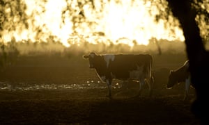
Has Australia not only sold off the land, the ports and now the water to foreign State-owned companies?
Does the FIRB protect Australia or facilitate the purchase of its assets?
How bad can it get?
THE two Chinese state-owned companies that have purchased Australian water entitlements are:
Unibale Pty Ltd listed as an Australian subsidiary of the state-owned COFCO Corporation, one of China’s major agriculture companies.
Unibale Pty Ltdowns more than 7,000 megalitres of water entitlements in the Gwydir River system
A COFCO subsidiary, Chinatex Australia has failed to pay a Federal Court order to compensate a local beef provider.
-they have acquired water entitlements and faced limited scrutiny by the FIRB
-the reduction of water in our major rivers has led to a rising price
-since 2014 trade in water allocations in the Murray-Darling Basin were relaxed
-though a commodity it does not have the same governance and due diligence like gold or minerals
-private foreign investors buying into our water market are exempt from restrictions to prevent a fire sale takeover of our Assets!
-unlike the alleged restrictions for land and real estate, water assets are not within the FIRB’s oversight
.except for direct purchase by foreign governments
-on their own water entitlements do not require FIRB approval
HOW can it be said that the FIRB balances Australia remaining such an attractive destination for foreign buyers having allowed all but five transactions yet ensuring these overseas acquisitions are not contrary to Australia’s national interest?
AND despite the Government introducing Public Registers to record these foreign acquisitions of these Australian asset classes it has been reported in The Weekly Times that the Deputy Prime Minister has backed up the government’s stance on delays in releasing the register of foreign investment.
HOW can it be said that this is about ‘foreign investment’ … when it is about ownership of vital assets and especially control of Australia’s natural resources?’
READ MORE FROM 7.30 ‘Chinese State-Owned Companiesbuy up
WOULD any other country allow an Australian Pension Fund to buy up a natural resource, and make money through speculatively exploiting a flawed process?
AND the list of bad reasons why this should not happen flows beyond this initial argument to expose the stupidity of the wholesale sell-off of AUSTRALIA as if the real owners of Australia’s natural resources … the PEOPLE of AUSTRALIA have no entitlements to see them remain in the country’s hands, SOVEREIGNTY does matter!
P.S. WE just heard the Canadian Pension Fund not only is the biggest water owner but they are also the owner of the massive almond orchards downstream!
More vertical integration … were they watching the Chinese doing it here for decades? So they have followed suit.
AUSTRALIA will soon be the higgest ‘bicycle park in the World’ with all its people left to bend over … put their heads in the sand, and their backsides exposed to park the bikes …
YES … CAAN has had to reduce it to this to spell it out!
WHAT a pack of weak short sighted opportunistic sycophants are our leaders and business community!
HOW MUCH LONGER ARE WE TO PUT UP WITH THIS AUSTRALIA?
MEANWHILE PLEASE START THE CONVERSATION … anywhere … and SHARE!
PSP Investments, a Canadian pension fund, could now be the largest owner of water in the Murray-Darling Basin
A Canadian Government-owned pension fund could become one of the largest private owners of water entitlements in the Murray-Darling Basin from today, owning roughly 2 per cent of all its available water rights.
Key points:
Tensions over water ownership and trading have been running high, especially in the southern Basin
A Canadian pension fund has been on a multi-billion dollar buying spree
The Australian Competition and Consumer Commission is reviewing Australia’s water markets
Canada’s Public Sector Pension Investment Board (PSP Investments) is the pension fund for the country’s armed forces, public servants, police and firefighters.
Now, through its wholly-owned subsidiaries PSP Bidco and Sooke Investments, it is the owner of Webster Limited, Australia’s fourth-oldest company.
The soon-to-be deregistered ASX-listed Webster Limited was already a significant owner of water entitlements, reporting 167,217 megalitres — one megalitre (ML) is 1 million litres — in its portfolio at September last year.
PSP’s previous investments in Australian agriculture means that now the deal is complete, the Canadian pension fund holds more than 200,000ML of water in the Murray-Darling Basin.
It will use this water to grow walnuts, almonds, cotton, and cereal crops, and is unlikely to ‘speculate’ on water because last year, despite the volume of water Webster owned, it still did not have enough for permanent crops and had to buy water on the expensive spot market.
Adding it up
A breakdown of Webster’s water portfolio provided to investors last year shows high security, general security, and supplementary water rights in the southern Murray-Darling Basin — the Murray and Murrumbidgee Rivers — totalling 133,790ML.
But 81,288ML of water entitlements from those systems will be transferred to KoobaCo, which PSP will only have 49.9 per cent control of, while former Webster chairman Chris Corrigan and director David Fitzsimons will own the remaining stake.
A joint venture between PSP and the Robinson family holdings in the northern Basin, Bengerang, gives it control of around 20,000MLof water there, according to Marsden Jacobs Associates principal Simo Tervonen.
Add the 89,085ML of lower Murray entitlements PSP purchased from Singaporean-based Olam at the end of last year and the total amount of water in the southern Basin owned by PSP grows to about 202,231ML.
“Assuming PSP will have control of water rights in excess of 200,000ML, it would definitely be one of the largest private water owners in the MDB, if not the largest,” Mr Tervonen said.
This year, with general security licences in NSW at zero per cent, Webster told shareholders it had to enter the temporary market to buy enough water to keep its permanent plantations of walnut and almond trees watered.
How much water is that?
According to Mr Tervonen, there were approximately 14,800 gigalitres (GL) — or 14.8 million megalitres — of surface water entitlements on issue across all catchments and entitlement classes in the Murray-Darling Basin.
Commonwealth and state governments, the largest owners of water in the Basin, hold 21 per cent of surface water entitlements for environmental purposes, leaving 11,700GL for other water licence holders.
Analysis by Marson Jacobs Associates suggested that once groundwater entitlements and conveyance water were removed from the equation, the pool of water available for irrigators was approximately 8,880GL, or 8.88 million megalitres.
“Let’s say a party owns 200,000ML of that pool — that would represent 1.7 per cent of all the consumptive pool,” Mr Tervonen said.
“If we ditch unregulated and conveyance water, 200,000ML [assuming it’s all regulated water] is 2.3 per cent of the consumptive surface water pool.”
Municipal water corporations, as well as irrigation infrastructure operators, are also among the largest holders of water entitlements.
Properties like Cubbie Station have significant water licences, but Mr Tervonen said because they were unsupplemented or overland flow licences, they were very different to licences in other states.
“So basically, on comparable terms, Cubbie’s holdings are only 93,000ML,” he said.
“The ATO foreign ownership register is also based on the nominal volume of the entitlement, not entitlement characteristics such as the volumetric limit.”
Outside the Basin, mining companies like Chichester Metals own around 450GL of water entitlements, and Pilbara Iron owns more then 210GL.
The figure in the Murray-Darling Basin was 9.4 per cent and includes groundwater entitlements, with 21.9 per cent of the northern Basin entitlements foreign owned and 5.5 per cent of southern Basin entitlements held by foreign interests.
Non-resident individuals, foreign companies, state-owned enterprises, and any company in which a foreign entity owns 20 per cent or more are considered to be ‘foreign’ under Australian law.
China holds top place with 732GL, with the US (720GL) and the UK (411GL) holding second and third place.
Canada was fourth with 212GL, but PSP’s recent acquisitions could nearly double Canada’s stake in Australian water entitlements.
The ABC spoke with two other people connected to Murray-Darling Basin water markets, and each agreed the ownership of a further 202GL would make the owner one of, if not the largest owner of water in the Basin.
NSW state Shooters Fishers Farmers MP Helen Dalton has been lobbying hard to introduce laws that would force corporate water owners and any politician who owns water entitlements to publicly declare what they own.
Ms Dalton has declared she owns 1,383ML of high-security water and 3,324 ML of general security water in the Murrumbidgee valley.
Following an 11,000-signature-strong petition submitted to the NSW parliament by Ms Dalton, state politicians will debate the merit of establishing a national water ownership register on February 27.
In information about the PSP deal released to investors and the ASX under the heading “Risks”, Webster said its share price was influenced by “reputational risks, particularly in connection with the water industry”.
The Australian Competition and Consumer Commission is currently undertaking a review of Australia’s water markets.
Webster Limited and PSP Investments were asked to comment on this story, but by the time of publishing neither had responded.
A scientist who predicted our current bushfire crisis four decades ago is ‘horrified’ we did not listen to his warnings on climate change.
In 1987 then-CSIRO scientist Dr Tom Beer pioneered the world’s first research into the link between climate change and worsening fire seasons.
It might seem obvious now, but Dr Beer’s research, published as ‘Australian bushfire danger under changing climatic regimes’, predicted that growing greenhouse gas emissions would have horrific consequences for Australia’s bushfire season.
For Dr Beer, this summer has been the worst told-you-so moment.
Dr Tom Beer. Photo: RSV
“For decades, climate scientists have been warning Australian governments about the escalating threat of catastrophic bushfire conditions because of climate change,” Dr Beer said.
“I am horrified that what my study found has now occurred and the fact this means it is only going to get worse,” he said.
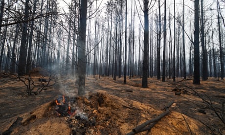
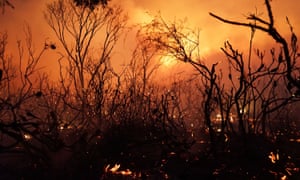
This year’s bushfire season started early and has killed 29 people, destroyed more than 2200 homes, burnt 10 million hectares and covered large areas of the globe in toxic smoke.
When Dr Beer started his research the Ash Wednesday fires of 1983 were the worst the country had seen.
“Since then, we have experienced the Black Saturday fires,had to create a new catastrophic fire danger rating, and in the past few months, we’ve seen 10 million hectares of Australia burn,” he said.
His research was presented at the 1987 CSIRO conference and published in a book. Dr Beer spoke to the media and travelled internationally to talk to specialists in the US about his findings.
*For the most part, it was ignored by the Australian government.
Not too late
On Wednesday the 72-year-old was joined by Professor of Pyrogeography and Fire Science at the University of Tasmania, David Bowman and the Climate Council’s Professor Will Steffen, in calling for urgent action.
“Climate change is fuelling the national bushfire catastrophe, and it will get worse without radical action,” they said.
*Calling for state and federal governments to work together, they said Australia needs an urgent plan to prepare for worsening fire seasons and to rapidly phase out the burning of coal, oil and gas.
“The length of the bushfire season has increased substantially, making it harder to prepare for dangerous conditions,” he said.
“The costs of fighting fires have also increased substantially, as have the costs of their impacts.
“Clearly, bushfire conditions are now more dangerous, and the risk will continue to escalate. The risk to people and property has increased significantly and will continue to do so.”
*Their calls for urgent action have been backed up by the business, medical and scientific communities here and abroad.
*Last month, a team of UK climate scientists conducted a rapid review of research conducted since 2013and found that human-induced climate change will cause an extra 20 to 30 severe fire danger days each year in the future.
We need to phase out coal to mitigate the climate threat. Photo: Getty
*The reason action on climate change has stalled is vested interests borrowing straight from the big tobacco playbook, spokesman for the Australian Lawyers Alliance, Greg Barns, said.
“In some ways, this is like the tobacco debate when we knew tobacco was harmful, that cigarettes caused cancer but governments ignored the advice,” Mr Barns said.
“There are some analogies between the way in which the big pharma and big tobacco litigation emerged, where there was clear and unequivocal advice given to governments which said that radical action had to be taken.
“Particularly in relation to planning and environmental decisions, in relations to the increase in bushfires, the strength of those fires and the length, as a result of climate change.
“Governments in effect ignored those reports, or worse than that, buried them. So there are some parallels.”
*The similarities in the situation could potentially lead to class actions against the government, Mr Barns said.
“For a government to deliberately ignore un-contradicted scientific evidence, that showed an increased risk of bushfires, weather catastrophes, is gross negligence and shows a complete lack of moral compass. *
“Speaking from a legal point of view, if it can be shown that the government has deliberately failed to implement policies when they had demonstrable evidence, that is a very serious matter.”
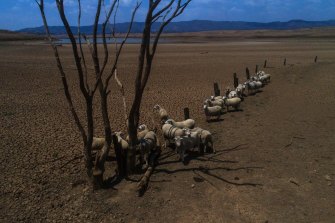
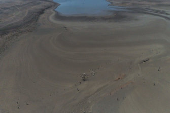
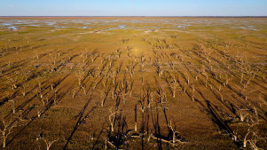
Water levels at NSW’s Burrendong Dam, which is three times bigger than Sydney Harbour, have dropped to a critical low of 1.6 per cent, with rain predicted for this weekend unlikely to help.
When full, the dam contains more than a trillion litres of water and supplies local irrigators as well as towns such as Dubbo and Cobar, in the state’s Central West.
The Herald’s Nick Moir captures how dry Lake Burrendong is due to the drought affecting the state.
Just three years ago, the dam was at overflow-levels of 120 per cent, before devastating drought conditions set in.
Now there are fears the dam, which spans the Macquarie River, will run dry and leave towns without a water source. In some areas, that could happen soon: modelling shows Dubbo may run dry by midyear, while for Cobar, regular water sources may fail by September.
“It should be scary for a lot of people,” Cobar council general manager Peter Vlatko said.
“The commitment from the government is that we won’t run out of water. But the difficulty is that the Burrendong is at 1.6 per cent.”
Sheep on a parched lake floor. Burrendong Dam is down to 1.6 per cent.CREDIT:NICK MOIR
The state government has promised Cobar will receive 80 per cent of its allocated water for 2020, Mr Vlatko said.
But old and faulty infrastructure has compounded problems, with a major pump failure in Hermidale late last year. Dubbo and Cobar residents have been placed on unforgiving water restrictions and miners have been told to save water.
An AGL hydroelectric station that normally uses run-off from the dam has also been taken out of action.
Meanwhile, local officials are scrambling to install additional pumps to extract water pooled below the dam’s usual outlets.
Burrendong Dam in drought as seen from a drone.CREDIT:NICK MOIR
There are also plans to divert water from the Windamere Dam, nearly 200 kilometres away. WaterNSW is meeting landowners and may release up to 25 gigalitres in early February, according to a WaterNSW official.
Under the plan, water would flow via the Cudgegong River and into the Burrendong Dam.
WaterNSW will assess whether the emergency top-up is necessary after this weekend’s forecast rain.
But it’s unlikely the rain will raise the water levels at Burrendong significantly.
“The soil’s so dry at the moment so it acts like a sponge,” University of NSW water scientist Stuart Khan said. “When that happens it takes a significant amount of rainfall to generate run-off.
“If we have 40 or 50 mm [of rain] then we might expect some good run-off. But 50 mm is not going to fill the lake. I think you need something like 50 mm to even start generating run-off.”
WaterNSW agreed that “significant” rainfall would be required to make a difference to the dam’s levels.
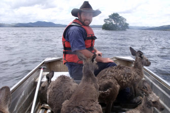
In its current state, Burrendong Dam looks unrecognisable compared with during flood years. In 1990 and again in 2010, deluges filled the dam to overflowing, with the catchment at more than 150 per cent capacity.
Wildlife, included kangaroos, were stranded, requiring a rescue operation by boat.
Wildlife conservationists rescue kangaroos from a flooded Burrendong Dam in December 2010.CREDIT:AAP/BURRENDONG SPORT AND RECREATION CENTRE
The last year of flooding was 2016, after which levels began to plummet.
Now, with dam levels so low, tourism and recreation have dropped off in the area.
Codey Swadling, from outside Orange, grew up waterskiing on the dam.
“It’s a significant loss for the people who regularly use the water for water sports,” he said. “[But there’s] a far more severe impact on the communities and business that rely on … these hobbyists.”
WaterNSW said “historic” dry conditions were responsible for the nearly empty dam levels.
Mr Swadling agreed he had never seen the dam in this condition.
“The landscape has been devastated. I can’t recall such a prolonged period of emptiness.”
On a hot summer’s day in Sydney, you only need to drive half an hour west before the mercury starts to noticeably jump.
Penrith was the hottest place on the planet at 47.3 degrees on January 7 this year. In Sydney, the temperature reached a comparatively meagre 44 degrees.
It’s a pretty standard story — the further you are from the ocean, the higher the temperature.
Rising global temperatures are one thing, but what if the actual design of your city is causing the thermometer to spike?
And while anyone close to the ocean can easily flock to the beaches on those hot sweaty days, people living out west have to find other ways to stay cool — which can often be expensive.
Western Sydney councils are banding together to tackle the growing heat problem, but it’s not as straightforward as you’d think.
How do you make a city cooler?
The Western Sydney Organisation of Councils (WSROC) represents eight councils trying to tackle climate change and the urban heat problem.
*It’s particularly pertinent because the State Government’s policy is to move another million residents to Western Sydney in the next 20 years.
*They want to build a new airport and the world’s largest incinerator — all of which that means more roads and more roofs.
Stephen Bali, mayor of Blacktown and president of WSROC, worries it will only get worse.
“There is a change in the climate between eastern seaboard versus Western Sydney,” he said.
“There’s also pollution effects, because we don’t get those winds that often clear the air.
“And we live in a basin so pollution is higher and hence the actual impact on people is higher.
“Cardiovascular disease, higher respiratory illnesses, every cancer rate that you can look at is higher in Western Sydney than on the eastern seaboard.“
“You look at the number of complaints that councils get [which] are people actually asking for trees to be cut down,” he said.
So even trees are not as simple a solution as you would think.
Thinking about the future
But people are getting there — it’s about generational change.
Councils are spacing out streets, they’re using reflective colours,planting trees, using heat sensors, holding design competitions, installing water features — these are just some of the things the west are doing to fix the city.
Western Sydney programs to combat urban heat:
Cool Parramatta
Turn Down the Heat
Blacktown’s Cool Streets program
Penrith’s Cooling the City Strategy
“You don’t have to have to have an argument about global climate change or anything,” Mr Bali said.
*“Manmade climate change in the Sydney basin will have an effect, there is no question about that. *
“So essentially how do we accommodate our health systems to recognise that there are these issues and apart from just building hospitals, which is an end product … we want to avert the illness.”
What is the urban heat island effect?
The urban heat island effect is caused when a metropolitan area is significantly warmer than surrounding areas due to human activity.
The biggest cause of it is hard surfaces, like roads, footpaths, roofs, as well as buildings.
They absorb the sun’s heat to send it rippling throughout the surrounding areas.
Jonathan Fox, a researcher at the UNSW in the faculty of built environment, looks at how to design buildings of the future.
He said the science is unequivocal — heat is a problem.
“We live in an urbanising world so more people live in cities, the cities are getting bigger and cities are getting hotter,” he said.
“And then we have a consequence of urbanisation, which is commonly referred to as the urban heat island effect.”
If you’re in a city today and you’re feeling hot, look around and you’ll start to notice all the things that make the heat worse, which add to the urban heat island effect.
These are things like dark concrete, no trees for shade, houses with dark roofs, endless paved roads as far as the eye can see.
“[The urban heat island effect] has been called inadvertent climate change, and there’s no doubt that the way cities have been constructed in the past, without knowledge of the climate effects of design, have exacerbated the overheating problem in cities,” Mr Fox said.
One city concerned about the rising heat is Parramatta.
The manager of Parramatta’s city strategy team, Geoff King, said when it gets hot in the Western suburbs of Sydney, it’s “scorching”.
“The data tells us that nobody goes out in the street, so people stay in their buildings,” he said.
“Once it gets over 35 degrees you get a major drop in pedestrian traffic. So I’d describe it as they scuttle from air conditioning to air conditioning.”
And when it heats up people stop going outside, they stop exercising and they stop buying things, which is bad for the economy.
Major infrastructure can deteriorate, and worst of all, people can get sick and die.
More people have died from heat waves in the past 100 years than every other natural disaster combined.
So Parramatta Council has a few different projects underway aimed at dealing with heat.
One of them is pretty simple. Lodged in the branches of different tree species are 20 temperature sensors — tiny little pieces of plastic stuck to tree limbs hidden from view.
It’s called Smart City project and is being run in cooperation with Parramatta parks and reserves workers.
“So it’s a really low tech, really flexible and easy way for us to monitor the temperature in the park under each of the tree species,” Mr King said.
“It basically logs temperature regularly for three months until the battery runs out and then it just becomes a USB stick.”
The council also have two water parks in operation — basically playgrounds covered in giant sprinklers.
Along with simple projects such as those, Parramatta Council regularly run design competitions for architects, asking them to rethink the design of buildings — like including awnings, reorienting the building’s outlook, and changing the materials
One of the questions Mr King raises is the trend of having dark roofs on houses and buildings.
“It’s an interesting question — why do we like dark roofs?” he said.
“I think it’s aesthetics related to what we know, and I’m going to hazard a guess here, I think the original colonial buildings that had Welsh slate on them came out as ballast in the ships.
“They were the top class, they were the top houses, and so they had black roofs.
“And I think over time we’ve associated black roofs with a quality finish and a high-class building, but in an Australian climate.
“So we’ve done a lot of research into roofs being a really simple way, the colour of roofs being a really simple way of reducing the energy load on your building.”
Mr King said the corrugated iron roofs found on more and more western Sydney homes work well, with the light silver colouring capable of reflecting the sun, instead of soaking it up.
All one has to do is take a thermal imager to areas like Epping. You can just see a massive thermal change by how much vegetation they have removed.
The actual buildings absorb heat and need vegetation where they have removed it
Trees will take decades, they need scrub bushes all over the buildings. And using recycled water to water them. And ban black roofs on the dodgy rezoned Mcmansions
The .8 median changes in temperature over the past 20 years proves why high density city planning is affecting the measurements at Sydney Observatory, and why it needs to be stopped being used as a data source.
Or at least the sensors connected to ethernet and fibre spread around the city; but they will still be affected by thermal mass.
At least it proves poor planning and compounding thermal mass is a big problem.
It is picking up changes from all the concrete, and motorways around it!
26.2 to 27 in January over 20 years. It’s exponentially caused by unsustainable slum cities.
That is a rise of 0.8 degree over 20 years in the Sydney CBD in January. Because of concrete thermal mass and over development. Heat coming off from cars on the motorway might add to it also.
Barrangaroo just at the back of it instead of being turned into a public green space; has been rubbished for absolute corruption. An abomination now turned over to Macau Casino mafia.
A summary of the major climate statistics recorded at this site is provided below. There is also an extended table with more statistics available. More detailed data for individual sites is available.
View: Main statistics All availablePeriod: Use all years of data 1991-2020 1981-2010 1971-2000 1961-1990 1951-1980 1941-1970 1931-1960 1921-1950 1911-1940 1901-1930 1891-1920 1881-1910 1871-1900 1861-1890 Text size: Normal Large
It starts innocently enough — a hairline crack on, say, the lounge room wall. But, before too long, that annoying little line creeps further down the wall and widens.
“In extraordinary dry times like now, those cracks will widen,” warned Professor Nasser Khalili, the head of geotechnical engineering at the University of New South Wales.
In the vast majority of cases, cracks in houses are caused when the soil underneath the house starts to dry and contract, causing the footing of the house to shift unevenly, which leads the walls to move and crack.
Clay soils are much more susceptible, or ‘reactive’, to changing moisture content than sandy soils because, like a sponge, they soak up or repel water.
“We’ve got this rare occasion now where we’re going without rain, significant rainfall, for months or, in some places,12 months and that means we have long periods where soil, which would otherwise not lose its moisture, is now losing its moisture,” explained Stephen Fityus, a professor of geotechnical engineering at the University of Newcastle.
That heat and dryness is not confined to the atmosphere around us — soil moisture content in December was also “very much below average” in parts of every state and territory except the ACT, according to BOM data.
“Soils continue to be extremely dry along the east coast of New South Wales and the fraction of the state experiencing very much below average soil moisture in December has increased to 48 per cent, compared to 25 per cent in November,” the bureau said in its December drought report.
As the soil beneath us dries up, plants and trees are trying to stay alive, desperately sucking up whatever moisture they can get from the ground, which is drying the soil even more.
“This is an extreme event, and there’s no surprise there’s a correlation to soils around the country being drier than they’ve ever been before and the drought,” said Professor Fityus.
Many Sydney homeowners have noticed new or worse cracks appearing just in the last month or so.
Cracks spread across the walls and ceiling of this house in the Sydney suburb of Marrickville while the owner was away for two weeks at Christmas. Photo: Sandra Eckersley
Sandra Eckersley told ABC News that she was disturbed to find the upstairs of her 1891 house in Marrickville had cracked extensively while she was away for a fortnight on a Christmas holiday.
“I’ve had cracks here before, but this is the worst ever. This is extreme.”
Ms Eckersley said the movement has been so extreme that she can only keep her back door closed by locking it.
This house in Sydney’s inner-west was built in 1891, and its current owner has never seen it cracking this badly before. Photo: Sandra Eckersley
Meanwhile, further north in Epping, cracks at Sandra Williams’ 1922 home appeared just a few weeks ago.
“The first major crack I noticed was in the brickwork out the front of the house,” she told ABC News.
“It’s about two metres long and about the width of the mortar, it goes around a corner of the house and up the window frame.
“I noticed it a few days before Christmas, the day after that really hot 40-degree day.”
A jagged crack winds its way along the external brickwork of this hundred-year-old house in north-west Sydney, January 2020. Photo: Sandra Williams
Archicentre Australia managing director Peter Giorgiou said building regulations need to adapt to the warming environment.
“We can’t rely on that seasonal benefit anymore. We’ve got to be a lot more proactive in the way we understand how to manage our buildings in a newly defined era,” he said.
“To that end, the standards we’ve set in the past need to change as well.”
What should you do if your house is cracking?
The ancient Japanese art of Kintsugi, where broken pottery is stuck back together with gold, celebrates the beauty of the cracks.
That is the attitude some experts say homeowners should take about the cracks in their walls.
“If buildings are in areas that are susceptible to shrink and swell, those cracks are non-structural and shouldn’t affect the structural integrity of the building,” said Professor Khalili.
“The usual approach is not to correct them, not to fill them in and patch them because next year again they will reappear in a worse condition.
“They are living buildings — during summer they open, during winter they close.”
The building or engineers department of your local council may be able to provide information about the type of soil your house is built on, or you can check to see if it has a geotechnical investigation of your property done as part of a development permit submission.
Even in areas with reactive soils prone to expansion and contraction, Professor Fityus said there are ways to mitigate against cracking.
“You can build bigger foundations under the house at the start, but that’s expensive,” he said.
However, in an established house, once you have got cracking, it is very hard to stop it.
“You can try to stop the soil from moving, and you can only do that from stopping it getting wet and dry,” Professor Fityus said.
One option is to cut down all the trees on your property.
“But cutting them down can be problematic, because if the tree is established it already has a moisture regime happening and if you cut it down suddenly you’ve got more moisture in the soil than you did before,” he added.
Another option is to put paving all around the house.
Hallway cracks in a federation house in Sydney’s inner-west, probably caused by dry soil. Photo: ABC News
“So, if you put a one-metre wide concrete slab around your house and you seal it up against the walls, you move the wet to dry boundary away from right under your walls,” explained Professor Fityus.
He said watering lawns is a tricky solution.
“Some people water their lawns to excess and, if you do that, you’re likely to put more water around your house than under it, which will also cause things to move.”
In short, there are no easy fixes and the advice from Professor Fityus is to call in a professional if you are concerned.
“Almost every situation needs to be looked at by someone who knows what’s going on to offer specific advice,” he said.
But all three experts warned of being careful who to get advice from, with some operators biased in favour of using their own product or ‘cure’.
They all agree an independent assessment from a structural engineer or building consultant is a good first step before spending thousands of dollars on any remediation work.
“Aboriginal and non-Indigenous Australians all understand that by lowering a flag we acknowledge that something has died or that something is dying. It is a symbol of mourning. There are so many people who are feeling anguish.”
An Aboriginal woman from Victoria is hoping that First Nations people and organisations around the nation will join her university in flying Indigenous flags at half mast, to acknowledge the grief Aboriginal people are feeling at the destruction of Country from Australia’s ongoing bushfire crisis.
Associate Professor Gabrielle Fletcher is a Gundungurra woman from the Blue Mountains of New South Wales. She’s also a Professor in Indigenous Studies and the Director of the Institute for Koorie Education at Deakin University in Melbourne.
“To lose Country, in this way, is a particular grief for Aboriginal and Torres Strait Islander people. It’s a messy grief,” Associate Professor Fletcher told New Matilda.
“It’s more in sorrow than anger, it’s mourning. You could say it’s ‘Sorry business’ in a way.
Associate Professor Gabrielle Fletcher.
“As a collective, this symbolic gesture may provide somewhere for all Australians to leave parts of this despair.
“It’s also a reflection of the immense grief of guilt where we feel a kind of irresponsible helplessness – our sense of the abandonment of our cultural obligations to Care for Country.”
Deakin University is already flying the Aboriginal flag at half mast today, after a request from Associate Professor Fletcher this week to the Vice-Chancellor, Professor Iain Martin, with the gesture receiving “overwhelming” support from Deakin faculty and students.
Professor Fletcher is hoping it might spread across the nation, and that “these lowered symbolic fabrics become the message sticks for urgent change”.
Aboriginal flags at Deakin University in Victoria are flying at half mast, to acknowledge the grief Aboriginal people are feeling at the loss of country in the ongoing Australian bushfire crisis.
“Aboriginal and non-Indigenous Australians all understand that by lowering a flag we acknowledge that something has died or that something is dying. It is a symbol of mourning. There are so many people who are feeling anguish.”
Assoc Prof Fletcher said the scale of the loss felt by First Nations people was enormous, and it wasn’t just restricted to the land and its animals.
“Country moves beyond landscape, allotment, vista or wildlife as stand-alone components. It is also place, Ancestors, shadows, mist, warble, maps and vapour,” she said.
The aftermath of the fires on Kangaroo Island, South Australia, in January 2020. (IMAGE: Chris Graham, New Matilda)
“When Aboriginal People lose Country to this scale we lose Knowledge, Ways, Forms, Spirit and Healing – these are a complex interconnection, where everything has its place to teach, feel, show and speak.
“With each loss we slip further away from understanding who we are, and how we fit – this is the ultimate death in many respects.”
Assoc Prof Fletcher acknowledged there were some positives to come out of the fire crisis, beyond waking people up to the realities our nation faces.
“People are starting to recognise and acknowledge the validity and value of Indigenous Knowledges, and ways of knowing, being and doing. It’s been an uncomfortable discovery for some.”
The fires on Kangaroo Island, South Australia in January 2020. (IMAGE: Chris Graham, New Matilda)
Assoc Prof Fletcher hopes that other organisations follow suit and lower their Aboriginal flags in the aftermath of the bushfire emergency.
“I think this action symbolically describes the collective realisation that we’ve lost so much more than what can be seen and is a true wake-up call.” Professor Fletcher said.
“On behalf of the Institute of Koorie Education, I thank Deakin Vice-Chancellor Professor Iain Martin for his support in this unprecedented gesture.”
If you’re supporting this story on social media, please use the hashtag: #HalfMastForMyCountry
New Matilda is a small, independent media outlet. We survive through reader contributions, and never losing a lawsuit. If you got something from this article, giving something back helps us to continue speaking truth to power. Every little bit counts. TAGS: chris grahamFacebookTwitterGoogle+LinkedInmorePinterestTumblrEmail
Chris Graham is the publisher and editor of New Matilda. He is the former founding managing editor of the National Indigenous Times and Tracker magazine. Chris has won a Walkley Award, a Walkley High Commendation and two Human Rights Awards for his reporting. He lives in Brisbane and splits his time between Stradbroke Island, where New Matilda is based, and the mainland.
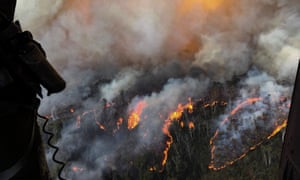
The unprecedented bushfires could affect the diversity of eucalypts for which the Blue Mountains is recognised. Photograph: CPOA Brett Kennedy/Commonwealth of Australia/PA
At least 80% of the Blue Mountains world heritage area and more than 50% of the Gondwana world heritage rainforests have burned in Australia’s ongoing bushfire crisis.
The scale of the disaster is such that it could affect the diversity of eucalypts for which the Blue Mountains world heritage area is recognised, said John Merson, the executive director of the Blue Mountains World Heritage Institute.
The data is based on a Guardian Australia analysis of areas burned in New South Wales and Queensland and was confirmed by the NSW government.
Guardian Australia reported in December that 20% of the Blue Mountains world heritage area had been affected by fire in the early months of the crisis.
Four times that amount has now burned in what Merson said were fires of a scale that “has never happened before”.
“This is totally, totally unique. As everybody keeps saying, it’s unprecedented,” he said.
The Blue Mountains world heritage area covers one million hectares of national park and bushland and is dominated by temperate eucalypt forest.
The area is renowned for the diversity of its vegetation and is home to about a third of the world’s eucalypt species.
While most are fire-adapted and can regenerate, many of the species depend on long intervals between fires, Merson said.
“We had a very large fire in 2013. It’s only six years after that,” he said.
“The eucalypts can be very badly reduced in diversity if fires come through in too short and intense intervals. Their numbers will virtually collapse.”
He said the full impact on tree species and wildlife would not be known until more assessments were done as fire grounds became accessible.
But there are concerns about the effect on breeding and feeding habitats for species including the spotted-tail quoll and the brush-tailed rock-wallaby.
The fires have also burnt swamp communities that release water slowly and are important water resources. They flow into streams that feed into Sydney’s water supply and provide water for wildlife.
It was revealed this week that a rescue mission by NSW fire crews was able to save the only known natural grove of Wollemi pines, so-called “dinosaur trees” that fossil records show existed up to 200m years ago.
Merson said the fires had entered areas that had not burnt previously and the need for the rescue mission was indicative of the intensity of the fires in the region.
Play Video0:55 Prehistoric Wollemi pines saved by firefighters from Australia’s bushfires – video
“This isclimate change in its most fundamental form,” he said.
“This is right in our face. We’re living it.”
Further north, the fires have devastated parts of the Gondwana rainforest world heritage area, a collection of reserves of subtropical rainforest that span 366,500 hectares across NSW and Queensland.
Graham said his area had experienced some rain in recent weeks but there were now concerns that sediment washed into the Bellinger River has affected the food sources for the critically endangered Bellinger River snapping turtle.
A spokesman for the NSW Department of Planning, Industry and Environment said understanding the impact of the fires on both world heritage areas was a priority.
“Analysis will improve as the forests becomes safe to enter and the smoke clears, enabling accurate satellite and aerial imagery to help guide our assessment and on work on ground,” he said.
He said both regions contained a mixture of forest types, some of which was adapted for fire, but others that were more sensitive to fire, such as dense rainforest.
Jess Abrahams, the nature campaigner for the Australian Conservation Foundation, said climate change was hitting Australia’s world heritage areas “very hard”.
“We have witnessed consecutive years of devastating coral bleaching on the Great Barrier Reef, while global heating has been described as a catastrophic risk to the Wet Tropics and Shark Bay world heritage areas,” he said.
“It’s really upsetting to see how much of the Blue Mountains world heritage area has been burnt.
“This is a place many Australians know and love. It has significant Indigenous cultural values and is home to a number of rare and threatened species.”


